Our research activity focuses on the study of the surface of Mars, with the aim of characterizing both ancient and present-time surface processes and evaluate landing sites for present and current exploration missions on Mars. We are deeply involved in the CaSSIS stereocamera on board the ESA ExoMars Trace Gas Orbiter (TGO) mission, which is currently orbiting around Mars and acquiring color images at a resolution of 4.6 m (click here to see latest released images!).
Our research activities on Mars have been finalized in a different sets of published articles, which are described and provided below.
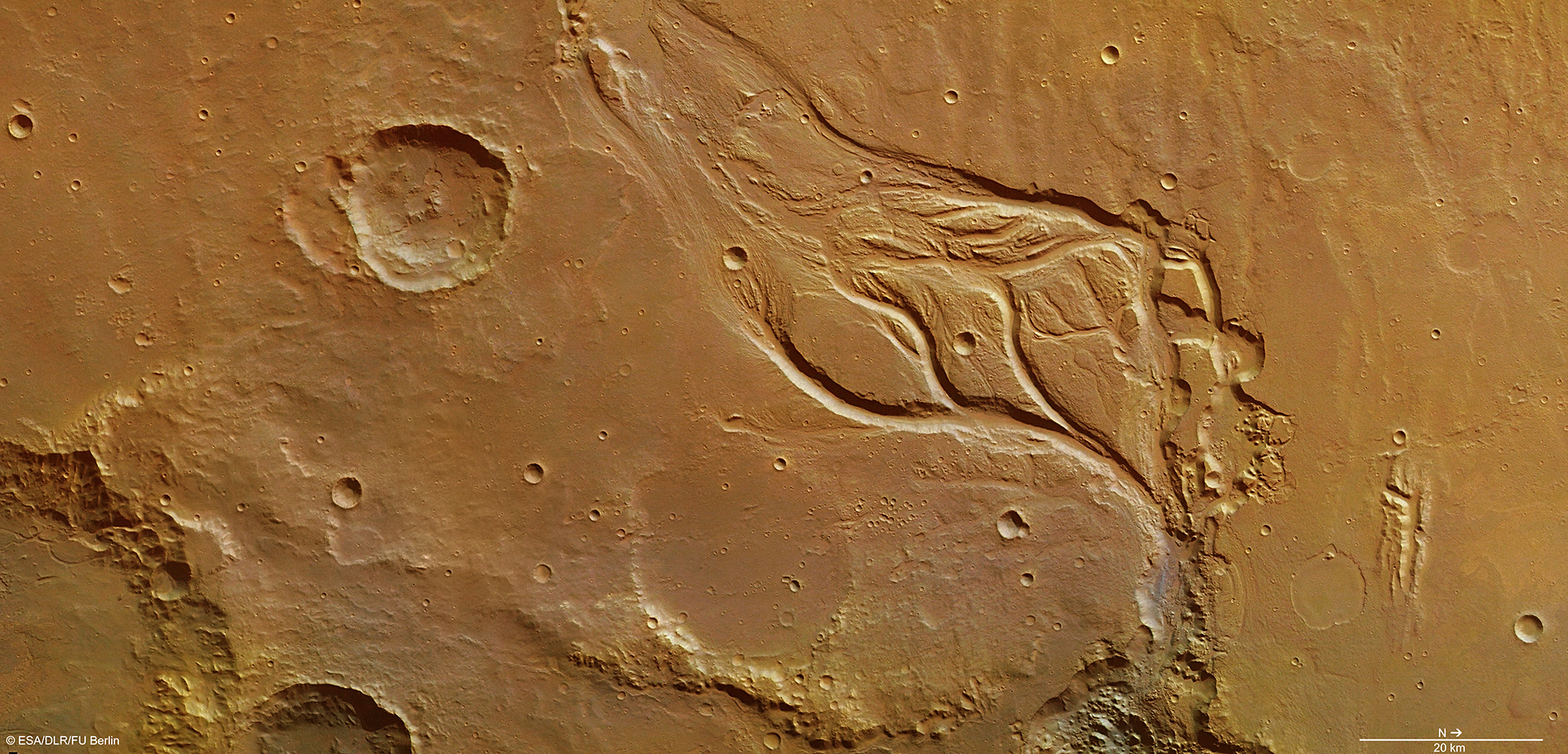
Landing sites selection
Part of our work is dedicated to study, characterize and propose new landing sites for present and future Mars exploration missions. In particular, we take into account all the engineering constraints that must be fulfilled in order to land on the Martian surface. To characterize its scientific potential we perform highly multidisciplinary analyses, taking into account many aspect such as the regional setting of site, its geologic history, its connection with past presence of water, its mineralogy and astrobiological implications.
For further details, the research work has been published in the following articles:
- Pajola, M et al., 2017: Boulder abundances and size-frequency distributions on Oxia Planum-Mars: Scientific implications for the 2020 ESA ExoMars rover, Icarus, 296,73-90.
- Pajola, M et al., 2016: Eridania Basin: An ancient paleolake floor as the next landing site for the Mars 2020 rover, Icarus, 275, 163-182.
- Pajola, M et al., 2016: The Simud–Tiu Valles hydrologic system: A multidisciplinary study of a possible site for future Mars on-site exploration, Icarus,268,355-381.
Phobos
We are working on the spectrophotometric and morphological analysis of the Mars satellite Phobos, using images taken in the Visible, Near-Ultraviolet and Near-Infrared wavelength range (MRO-CRISM and ExoMars/CaSSIS), coupled with its 3D shape. The aim of these studies is to help understanding the still-debated origin and the mineralogical composition of this object, together with its surface evolution.
For more information, we remind you to the following articles:
- Pajola, M. et al., (2012): Spectrophotometric investigation of Phobos with the Rosetta OSIRIS‐NAC camera and implications for its collisional capture. Monthly Notices of the Royal Astronomical Society, 427: 3230-3243.
- Pajola, M. et al., (2013): Phobos as a D-type captured asteroid, spectral modeling from 0.2 to 4 μm, , ,
- Simioni, E. et al., (2015): Phobos grooves and impact craters: A stereographic analysis,Icarus,256,2015,90-100
- Pajola, M. et al., (2018): Phobos MRO/CRISM visible and near-infrared (0.5–2.5 μm) spectral modeling,PSS,154,2018,63-71
- Stooke P., Pajola M. (2019) Mapping Irregular Bodies. In: Hargitai H. (eds) Planetary Cartography and GIS. Lecture Notes in Geoinformation and Cartography. Springer, Cham
Martian paleohydrology
Our research is also focused on the study of landforms which testify past water activity both on the surface (paleo-river beds, paleolakes and fluvial valleys) and in the subsurface. Concerning the first, we studied in detail the Eridania basin and the Simud-Tiu Valles hydrologic system, in the framework of proposing landing sites for future Mars exploration missions (see the references above). Moreover we are interested in the characterization of past water-rock interaction originating from subsurface water reservoirs. In this context we recently investigated mound fields, in Arabia Terra, Mars, constraining the presence of a pressurized fluid reservoir at depth and the past fluid upwelling and circulation.
Source:
Present time surface process
We are starting to investigate surface features occurring at the present time on Mars, which may provide us a deeper understanding of the present-day Mars. In particular, we are interested in the ubiquitous Recurring Slope Lineae (RSL). These recently discovered surface features do not have, at the present time, a clear explanation and may be related to liquid flows. In this framework, we use HiRISE (25-cm resolution) and CaSSIS (4.6 m resolution) images in order to study these features and gain insights in their origin and evolution.
Sources:
- , et al. ( 2007), Mars Reconnaissance Orbiter’s High Resolution Imaging Science Experiment (HiRISE), J. Geophys. Res., 112, E05S02
- Munaretto, G., et al. (2018): Global properties of Martian Recurring Slope Lineae,EPSC Abstracts,Vol. 12, EPSC2018-269, 2018.